
Surveying with a drove offers enormous potential to Geographic Information Systems (GIS) professionals. The drone allows topographic surveys to be carried out with the same quality as highly precise measurements gathered by traditional methods but in a fraction of the time. This significantly reduces the cost of site surveys and the workload of specialists in the field.
What Is Meant by Drone Survey?

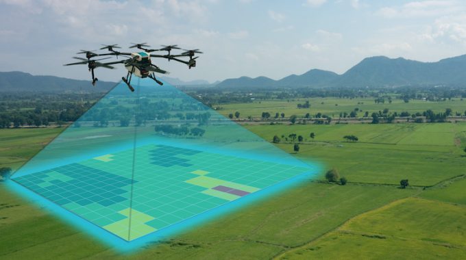
Drone surveying refers to using a drone or unmanned aerial vehicle (UAV) to collect airborne data using down-looking sensors such as RBG or LIDAR payloads. In a drone survey with an RGB camera, the ground is imaged multiple times from various angles and each image is referenced with coordinates.
Photogrammetry software can create orthomosaics, elevation models or 3D models with the georeferenced project area. These maps can also be used to obtain information such as exact distances or volume measurements.
Unlike crewed aircraft or satellite imagery, drones can fly at much lower altitudes, making the generation of high-resolution, high-precision data, much faster, cheaper and irrespective of atmospheric conditions.
What Are the Advantages of Drones in Mapping?
Reduce Survey Costs and Field Time
Collecting topographic data by drone is up to five times faster than ground methods and requires less manpower. PPK geo-tagging also saves time by eliminating the need to install multiple GCPs. Therefore, the survey results are quicker and at a lower cost.
Provide Accurate and Exhaustive Data
Total stations only measure individual points. A single drone flight provides thousands of measurements that can be presented in different formats (orthomosaic, point cloud, DTM, DSM, contour lines, etc). Each pixel or 3D model point on the produced map contains 3D geodata.
Map Otherwise Inaccessible Areas
An aerial mapping drone can fly almost anywhere. You’re no longer restricted by inaccessible areas, unsafe steep slopes or rugged terrain unsuitable for traditional surveying tools. You don’t have to close roads or train tracks. In fact, you can capture data on the fly without any organizational upkeep.
What Are Drones Used for in Surveying?
Land Surveying / Cartography
Survey drones can produce high-resolution orthomosaics and detailed 3D models of areas where low-quality, outdated or incomplete data are available. They allow the rapid and easy production of high-accuracy cadastral maps, even in complex or inaccessible environments. Land surveyors can also extract features from images, such as signs, pavements, road markers, fire hydrants and sewers.
After post-processing with photogrammetry software, the same images can create highly detailed elevation models, contour lines and breaklines and 3D reconstructions of land or buildings.
Land Management and Development
Aerial photographs taken by drones significantly speed up and simplify topographic surveys for land management and planning. This applies to site reconnaissance, land planning and design, as well as the final construction of roads, buildings and utilities.
These images also form the basis for the creation of detailed topographic models for pre-construction engineering studies. The collected data can also be exported to any CAD or BIM software, so engineers can immediately start working on the 3D model.
Data collection using drones is easily repeatable at a low cost. Therefore, images can be taken at regular intervals and overlaid on the original plans to assess whether construction progresses to plan specifications.
Precise Measurements
High-resolution orthophotos enable surveyors to perform highly accurate surface and distance measurements.
Stockpile Volumetric Measurements
Using 3D mapping software, it is also possible to obtain volume measurements from the same images. This fast and cheap volume measurement method is handy for calculating reserves in mines and quarries for inventory or monitoring purposes.
With the drone, surveyors can capture many more topographic data points and thus, more accurate volume measurements. They can also do this much more safely than if they had to record data manually by walking up and down the reserves. Because the drones collect data from above, there is no interruption to the work on the ground. The short data collection time allows capturing the object’s current state at a specific moment in time.
Slope Monitoring
Automatic GIS analysis allows separating slope measurements from DTMs and DSMs generated from drone images. Knowing the steepness of the ground, areas can be classified and used for slope monitoring, including landslide mitigation and prevention.
Orthomosaics taken at different times can be used to detect changes in ground motion and measure its speed. These data can help anticipate landslides and avoid potential damage to railways, bridges and roads.
Compared to traditional monitoring methods, where sensors are placed at individual points, drones allow more comprehensive data collection. PPK-capable drones, which do not require the installation of multiple GCP points, are optimal for this application as these areas are often inaccessible.
Urban Planning
The development of increasingly complex urban areas requires high-level planning and therefore, time-consuming and costly data collection. Thanks to drones, urban planners can gather large amounts of updated data in a short amount of time and with far fewer staff. The images thus obtained allow planners to study the existing social and environmental conditions and consider the impact of different scenarios.
Drone mapping has become increasingly popular in this day and age. If you are looking to hire a professional in drone mapping, we recommend Flat Out Surveying. With over ten years of experience, they provide accurate and cost-effect surveying solutions. Their drone mapping service the region of Echuca, Bendigo and Shepparton.